


Jura Pic de l’Aigle Belvédère des 4 Lacs

c.gourme
User
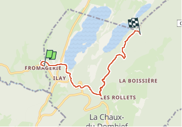

Length
5.6 km

Max alt
991 m

Uphill gradient
267 m
Km-Effort
8.6 km

Min alt
770 m

Downhill gradient
97 m
Boucle
No
Creation date :
2022-05-24 12:23:48.0
Updated on :
2022-05-24 14:51:15.833
2h27
Difficulty : Medium

FREE GPS app for hiking
 SityTrail
IGN / Geographical institutes
SityTrail Plus
The world is yours!
About
Trail Walking of 5.6 km to be discovered at Bourgogne-Franche-Comté, Jura, Le Frasnois. This trail is proposed by c.gourme.
Positioning
Country:
France
Region :
Bourgogne-Franche-Comté
Department/Province :
Jura
Municipality :
Le Frasnois
Location:
Unknown
Start:(Dec)
Start:(UTM)
720670 ; 5166750 (31T) N.
Comments